Medium Resolution Imaging Spectrometer (MERIS)
Source:http://www.naturalsciences.be Source: http://mtp.jpl.nasa.gov MERIS is a programmable, medium-spectral resolution, imaging spectrometer operating in the solar reflective spectral range. Fifteen spectral bands can be selected by ground command. The instrument scans the Earth's surface by the so called "push-broom" method. Linear CCD arrays provide spatial sampling in the across-track direction, while the satellite's motion provides scanning in the along-track direction. MERIS is designed so that it can acquire data over the Earth whenever illumination conditions are suitable. The instrument's 68.5° field of view around nadir covers a swath width of 1150 km. This wide field of view is shared between five identical optical modules arranged in a fan shape configuration. MERIS coverage for the SMAPEx study area is summarised in the table below. MERIS data can be downloaded from ESA.
Mission
MERIS
Sensor
Medium Resolution Imaging Spectrometer (MERIS)
Spacecraft
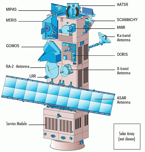
Envisat
Launch date
1st, Mar. 2002
Design life
3 years with a goal of 5 years
Orbit
Sun-synchronous polar orbit (SSO): Nominal reference orbit of mean altitude 800km, 35 days repeat cycle, 10:00am mean local solar time (MLST) descending node, 98.55°. inclination. [envisat.esa.int]
Spacecraft operations control centre
ESA
Accuracy
Ocean colour bands typical S:N = 1700
Swath (km)
Waveband
Spatial resolution (m)
Ocean: 1040m x 1200 m, Land & coast: 260m x 300m
Temporal resolution
35 days repeat cycle

MERIS overpass time
The MERIS overpass times for the SMAPEx study area have been determined from a Fortran program based on the NORAD data, and are provided in the table below. Date and time are in UTC.
●=full MERIS coverage of airborne box; ○=partial MERIS coverage
●=concurrent; ●=non concurrent
Date (UTC) |
MERIS overpass (UTC) |
Duration (s) | Flight Type |
|
|
155 |
|
|
|
159 |
|
|
|
95 |
|
|
|
84 |
|
|
|
- |
|
|
|
176 |
|
|
|
177 |
|